Dateline: July 17, 2018
I can’t tell you what Kendall Katwalk looks like, because after some 17 miles of a 12-mile hike, and 9-1/2 hours on the trail, I didn’t get to it. But I’m ahead of myself.
It’s not my usual start to a hike, nor my usual region. I spend the night in Seattle with the family so I can get an early start for a hike in the Mt. Baker-Snoqualmie National Forest. The Littles get up early, so it isn’t difficult to be on the road at 5:15. Missing my lovely coffee kiosk in Centralia, I have to settle for Starbucks, the only thing open.

The adventure begins with two interstates rather than SW Washington back roads. The trailhead is just 2/10ths of a mile from I-90; and now I know one of the upsides of the miles of potholed, washboard forest service road routes to trailheads: the trails are miles from the madding crowd. The roar of traffic accompanies me for much of the hike, and the stupendous views of the Alpine Lakes Wilderness include the interstate and the Alpental ski resort at Snoqualmie Pass.

I’m on the trail (part of the Pacific Crest) before 7am, while the temperature is still refreshing. It’s going to be another hot one before I’m done, but I plan to miss the worst of it. It’s a 12-mile hike with 2600 feet elevation gain, both of which are at my limit. Though not super steep, the trail is relentlessly up, for a long time. It’s not the most beautiful forest I’ve been in, and other than a couple of stream crossings, it’s monotonous. The other advantage of FS road approaches: a lot of the upshit is in the car and the trailhead is closer to the payoff point.
It gives me plenty of time for reflection. Of course my thoughts turn to my mother, a relationship that is now frozen in time for the rest of my life. I can’t change it, but I can better understand it. I continue to speculate on her shame at not caring well for her mother (her belief), and her obsession with “helping” me not have the same regrets.
First of all, while of course I have regrets, I know I could not have done better. I can re-story the past—cast it in a different light—but I can’t change it. She was who she was and I am who I am. That doesn’t change because she’s gone. My mother, however, had re-storyed her relationship with her own ancient mother into some falsehood she spent the next 30 years being mired in guilt over. “Someday you will understand what it’s like to be old,” she told me, wanting me to understand right then.
As I walk, one foot in front of the other, the road noise a constant companion, my thoughts return again to how easily I forgot the challenges after she died. What I understood, because I educated myself, was that she could not (or would not) comprehend my attempts to reason with her. (Mostly I was never sure if that was a brain thing or a control thing.) And her brain could not assimilate multiple pieces of information thrown at her at once, i.e. normal conversation. What I also understood was that understanding that did not make it any less frustrating. Probably there are more patient people than I; I was and am, at least outwardly, more patient with people who are not my mother. You can’t ever leave your ancient history with your mother behind. I forgave myself in advance for any sorrow at not being able to do it better that might linger after she was gone.
I’m sure she had the same issues in caring for her mother. Her mother was maddening, and no amount of understanding that she was old could make my mother less frustrated and hurt. Difference was, she turned the re-storying after death into failure and shame at not doing it better.
My mother worked out her shame by telling her mother’s story for the rest of her life: on paper, on cassette tapes, and verbally to anyone who would listen. I suppose I am doing the same, seeking to reconcile any hurt between us, forgiving myself, forgiving her, hoping she forgives me.

Surprisingly, the two young women in the parking lot when I left don’t catch up to me until two miles in. By the end of the day I will see several pairs of women hiking together—college students, I surmise. I think of my mother hiking with her girlfriends in the Smokies, until they met men and probably never hiked without them again. It makes me kind of sad.
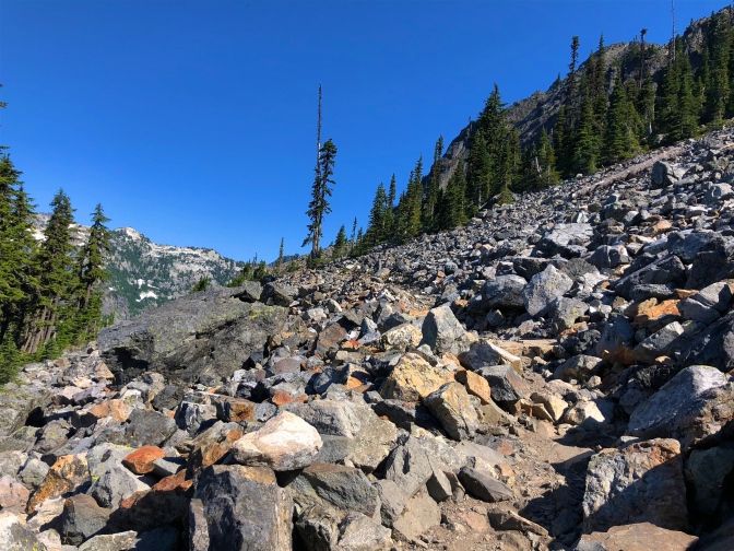
At one hour, the trail finally gets more interesting as it breaks out of the trees to cross a talus slope with a jaw-dropping view. A solitary pica scurries from rock to rock, but doesn’t let me take its picture. If I squint my ears, I can imagine the highway noise to be a rushing river. I build a cairn to help my mother find her way.


I plunge back into trees after resetting my mother’s pedometer that I finally remembered to bring, forgetting to press start at the trailhead. When I get back to the car I’ll add two miles.

I’m more than ready when I finally leave the woods behind for the rest of the ascent. Kendall Gardens, at 5000 feet elevation, is full of heather, bunch berry, penstemon, phlox, columbine, paintbrush, spirea (I’m trying to learn the flowers). Mt. Rainier graces the horizon behind me whenever I look back.


Some time later, in a snow patch, I take an overgrown path a few feet off the trail to a sweet overlook. Back to the snow patch, I continue.
I come to what I assume is Kendall Katwalk at what, according to the pedometer, is about the right mileage: maybe a bit over 6 miles. I had no intention of crossing what was described by its name and by the WTA as a narrow path blasted out of the side of a rock face. Though trip reports said it wasn’t really scary, I figured I had no need to prove to myself I could do it.


However, Mt. Rainier is peaking around the curve at the end, and I have that gosh darn curiosity about what’s around corners. It really isn’t bad at all and my aeroacrophobia doesn’t kick in. Or maybe I’ve just learned to channel my inner mountain goat; which reminds me, I really need to clean the roof.
I walk a few yards beyond, until the trail starts down, then turn around. When I get to the beginning side of the Katwalk, I reset my pedometer again, noting that it says four miles, plus the two I missed at the beginning, of course. This should be exactly half way, giving me a more accurate reading than adding on approximate mileage at the end. I pass the snow patch and stop beyond to eat my lunch. The bugs attack when I stop and I apply Vick’s Vapo-rub, which put the insects off but does nothing for the taste of my lunch.


As I walk again, a moth lands on the orange bear whistle that hangs from my pack. And stays and stays, slowly lifting its wings up and down. I begin moving again with it riding along, until a gnat flies into my mouth and I blow it out, blowing the moth off too. It reminds me of the time Mama said she had a stomach ache and told the hospice nurse she might have swallowed a fly, or maybe a lady bug. (She was serious. Read the story here.) Right after that, I see a ladybug on a flower stretching out into the trail. A true deep red ladybug, not those pale Asian intruders that fill my living room windows. Crazy. I think the moth (the first four letters of mother) is Mama’s spirit letting me know she forgives me, and sending the ladybug just in case I don’t get it.


That’s when I begin to sense trouble. It steals in as silently as the beating wings of the moth. Was the moth(er) warning me or reassuring me in advance that all would be well?
The trail doesn’t seem familiar, there weren’t this many snow patches on the way up, were there? I meet two young men who passed me on the way up and I’m more confused. I puzzle over it for the next mile. How could I have gotten to the destination ahead of them? I convince myself that they stopped somewhere or took a detour, otherwise I will think myself mad. But really, was there this much snow?
Then I spot a lake. There was no lake on the way up.

And a wide expanse of snow, which I cross, knowing there was absolutely nothing like this before. And it’s scary. The snow is getting soft and there are melted out holes that go way down to rocks below. It’s an invisible talus field, and the foot tracks across it are not over the solid path that will be obvious in coming weeks.

On the other side I meet another pair of young women.
“Is this the way to Summit West parking lot?” I ask them. They tell me it is. The way they are going. Not the way I am going.
“Kendall Katwalk isn’t that way?” I ask, pointing in the direction from which I’ve come.
“No,” they say, “it’s across there,” pointing the way they’ve come from, across a divide to another slope.
What the fuck? How did I mess up? Surely there were no other trails. They kindly tell me they got a little confused too. They ask if I crossed a narrow place. Yes. With a big lake below? No. I tell them I’m going just around the curve where they tell me there are two lakes; and that I’m not looking forward to crossing the snow field again.
I glance at the lakes and scurry back the way they were going, realizing I don’t want to lose them and spending not a second’s regret that I won’t see the Katwalk and I won’t be back. They’re going where I’m going and I suddenly wonder if I’m having a dementia event. My mother thought I suffered it. They finish crossing the field and feign a need to stop and rest. I think they are waiting to make sure the dotty old woman makes it. I’m not sorry they’re waiting. When they see that I’ll be fine, they leave. I hike fast to keep a visual on them, but eventually they are too fast for me.
I come to the first familiar snow patch again. There has been no trail I might have missed. But there must have been. I’m tired now and it’s hot. I’m scared. I don’t know what’s more terrifying: I’ve lost my mind or I’ve lost the trail. There are plenty of people up here, I know I’ll get back, so I just concentrate on where I left my mind.
I turn back the way I came again. I meet a trail runner (he’s not the first one, and they make me think I’m not the only crazy person up here), and ask him which direction the parking lot is. He tells me that’s where he’s headed and assures me I can’t miss it.
I turn around once more, cross the narrow trail I thought was the Katwalk for what I think is the third time, but is obviously the fourth.

I work out what must have happened. At that first snow patch when I briefly left the trail, I wasn’t paying attention and instead of continuing toward the Katwalk, I turned the way I had come from. The narrow chiseled portion of the trail must have looked different going the opposite direction and I didn’t recognize that I had been there.

I think I will never get back to the markers I know are coming: the shade, the stream crossing, the first talus slope, the picnic table just in from the trailhead. I’m exhausted. My feet hurt. Though I’m not aware until I empty the water bladder in my pack at home, I’ve consumed most of my water. It’s a couple hours after I get back to Seattle, that I realize the insects were biters and I itch from neck to ankles. The pedometer says 11 miles, I add the six I figured I hiked before the last resetting. No wonder I’m tired. (I’m not sure of the pedometer’s accuracy, since the length of a stride up mountains and over rocks, roots, and rivers are not the consistent length of those on a track.)
I let the family know I won’t be there for dinner and stop for a salmon burger and beer at the ski resort village. I need to relax before I hit rush hour traffic in Seattle. It’s not Basecamp Grill at Rainier, and Snoqualmie is not the Gifford Pinchot. It’s good to get out, but there’s no place like home, Dorothy.

Postscript: Turns out what I thought was the Katwalk really was the Katwalk. I did get there. And crossed it four times. The lake I almost got to was well beyond my destination. Vindicated.

What a hike! Thanks for the delightful post, glad you found your way safely home. Cathy
Sent from my iPhone
>
LikeLike
Thanks, Cathy. My car looked really good that day!
LikeLike
Maybe you need a GPS, particularly if you will be hiking above timberline. A GPS will give you direction speed and you can have it record a track. The better ones display your position on a map. Back before GPS I carried an altimeter, a topo map and a bearing compass.
LikeLike
I think I need to be more aware. I hate to depend on yet another device :-/. I already have a phone, a computer, a camera, a car I don’t really know how to use. One of things I like about hiking is no devices, just me! (I do carry my phone for the camera that takes better photos than my camera, and it has a compass.)
LikeLike
Your phone has a GPS built in. You can download a mapping app and use it IF you get side tracked by the scenery. No need to hike with it in your hand. Easy way to find out where you are.
LikeLike
Do I need to have cell service? I usually don’t, though I did this week.
LikeLike