I really needed a routine Thursday: coffee shop, yoga, grocery shopping, an afternoon at home. Four days of camping, 24 hours at home, and two nights in Seattle was taking a toll. But there were two available hiking days this week, and the better weather forecast was Thursday not Friday.
I wasn’t feeling it, again, but I trusted I would be happy when I hit the trail. The hiking season is oh so short here and it’s drawing to a close. Next week I have no available days, so not going wasn’t an option; but I did have to drag myself toward it.
My destination is across the road from the gorgeous wildflower-filled hike I did last week. The weather link on WTA says “mostly sunny,” after a rainy Wednesday. I leave home at 5am under heavily overcast skies. Call me skeptical. There is no sunrise over the prairie after I pick up my latte.
It’s raining in Packwood. I think of my cozy chair in the corner of the living room. I turn off US-12 onto WA-123. Misty. I pass the back entrance to Paradise, arrive at Cayuse Pass and turn onto 410. Heavy fog. I think of my Cinnamon Crunch bagel and coffee, while editing my memoir manuscript at the coffee shop.
I drive along the stone bordered road carved out of the wall of rock. There is no deep verdant valley over the edge, no Rainier ahead.

I brought a book, it’s only 7:30, I could sit in the car and read and see if it clears. I could hike in the fog and hope the trail rises above it. It will be good, I pep talk myself, whatever the weather. Still, I’m disappointed.
I round the last curve to Tipsoo Lake. I have no words.


Deep sigh.
A hiking friend and reader of my blog tells me she has come to expect me to get off course on my adventures, either in the car or on the trail. She won’t be disappointed this week. I carefully read the WTA directions (from Packwood this time, not Enumclaw, which is helpful): go to the second large parking lot, the trailhead [the Pacific Crest Trail] is behind the pit toilets. I follow it to the pedestrian overpass onto the section of the PCT I was on last week, not finding the expected spur trail. I cross the bridge anyway, but I don’t remember any turnoff to Sheep Lake.
I stand and ponder. I look at the map I took a phone photo of and check my compass. I don’t understand. I return to the parking lot with already nearly a mile on my pedometer. A young woman approaches me. She and her friend are looking for the Tolmie Peak/lookout trail. Well, I know where that one is! It could not be farther away and still be in the Mt. Rainier circle; it will take hours to drive there. They are farther off base than I am. I get a Park map out of my car and show them where it is. Grateful for my help, and on my recommendation, they decide to do the Naches Peak Loop I did last week.
The five cars in the lot when I arrived has now tripled in number. I ask two people if they know the Sheep Lake/Sourdough Gap trail. No. I decide I had to have missed something. The sun is full on and I leave the jacket I needed 45 minutes ago in the car and start up the trail again. And there it is, a scramble up a hillock and a 180º turn in the opposite direction. Once I see it, I can’t unsee it; but I sure missed it the first time while not knowing to look for it. This is wilderness land, not the national park, and signage is not a thing.

The occupants of the cars are obviously on the other trail, which is fine with me. I meet a backpacker snacking on huckleberries and no one else as the trail rises higher and higher above the road before turning away into the trees toward the lake.

At Sheep Lake, I meet 67-year-old Vivian, trail name “Rhinestone.” She’s hiking the Washington segment of the PCT in sections. This is her third outing. She slept last night in the pouring rain. She doesn’t know what she will do when she finishes Washington. “Oregon!” I offer. I’m so impressed. You know that question: who would you most like to have dinner with? All the inspiring over-60 solo women hikers would be my choice.


The flowers that were so spectacular on the trail across the road nine days ago, are gone, save for a few paintbrush, old man on the mountain, and nearly spent asters.

Far above the lake, I spot Mt. Adams rising above the fog. I’m not sure where Rainier is, maybe in the cloud bank. I may not see her after all. I round a curve though, and there is her top peaking over a gap. St. Helens must be in the clouds.


Sourdough Gap comes up unexpectedly at a switchback. I round the curve and it’s right there. It’s anticlimactic, not like Pinnacle Saddle where I went last summer and the two sides were like leaving Kansas for technicolor, but still I am awed to have come through the ridge to what’s on the other side, like the legendary bear. It’s also windy, and cold. I’m sorry I left my jacket behind.

One of the WTA trip reports said not to stop here, there is a best view farther on. I cross the scree field and, what ho! there’s the backside of signage. The report said take the unsigned left. I don’t know if this is where they meant or back at the gap, but another report said don’t go down, which is clear to me anyway.

I continue across the slope and scramble across the not-quite-a-trail over the next ridge above yet another bowl. And the edge of the Park! And Herself!

Now we’re talkin’. It’s only 10:30, but it feels like lunch time. Wishing again for my jacket, I find a protected rock and eat half my trail bar and apples and cheese. I decide to wander a bit farther up the trail. It’s the highlight of the hike.

After 45 minutes alone in this beautiful spot on Earth, a hiking group arrives and I head back toward the Gap. I chat for a bit with a PCT hiker, encouraging him to take the .4 mile detour to the view of Crystal Lake and Rainier—which he’s not going to see when he follows his route down into the bowl on this side. I bet he didn’t do it.
I nearly meet with catastrophe on a scree slope beyond the gap. A woman several feet beyond me wrestles her large, uncooperative dog to the upside of the narrow trail so I can pass. Just as I get to her, her feet slip on the rocks and she loses her grip on the dog who lunges at me. I plant my feet and poles as she reels in the dog, and I don’t go over the edge this time. Dogs are not allowed in the MRNP, but I’m not in the Park. I like the Park.
I meet three more 60-something women who ask if I went to the Gap. I encourage them to continue beyond. They thank me for the trail report. I imagine they did it.
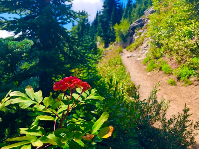
Back in the car, after huckleberry snacks and noticing the brilliant berries of the Sitka mountain ash I missed on the way up—harbingers of autumn—I drive past Tipsoo Lake and round the curve; the fog is back. Or maybe it never left here. Maybe I was in Oz.


Enjoyed your story. thank you
LikeLiked by 1 person
Thank you for reading, Ryan!
LikeLike